Wednesday 30 September 2009

OSGB GRID REF. SX329852. LAUNCESTON

TRIG. POINT ON SOURTON TOR
BAA, BAA
BROTHER PAUL & MUM IN LAUNCESTON
LAUNCESTON CASTLE
Although shared dorms are the norm in a Youth Hostel, occupation at the Okehampton establishment was low so I had a room all to myself. I didn't wake until 8.30am on Monday 28, which probably goes to show how much I needed the rest. I had to dress quickly to be in time for breakfast. 

It was great not to have to worry about dismantling the tent and packing the rucksack. I spent the day washing socks, writing my blog, sending some emails and dropping in on friend Alan at his electronics factory in Okehampton, but really not doing that much at all. 

I had decided to walk the whole of the Two Castles Trail in one go on Tuesday. This 24 mile path runs between Okehampton Castle and its counterpart in Launceston. It is the only footpath in the West Country that I walk in its entirety, the other footpaths I encounter being just short sections of longer paths. 

Rising early, I set off shortly after 8.00am. I had left my main rucksack at Alan's factory when I visited him so that I would only need to carry a few essential items in my lightweight daysack.T

The walk initially took me through a golf course and then up on the northern edge of Dartmoor National Park. Here I could free-roam for the first time since the Pennines, unconstrained by any path, much like the sheep surrounding me. One group of 5 sheep, 3 rams and 2 ewes, all decided to urinate simultaneously as I passed by. I came to the conclusion that this was probably some sort of collective insult to humans. I don't blame them. I too might be tempted to insult someone who was planning to eat me. 

The 'official' route of the Two Castles Trail is a bit tame so I took a detour up to Sourton Tor where the rocky summit provided me with a brief reminder of what Dartmoor is all about. Leaving the moor and continuing west, the remainder of the walk to Launceston was dull by comparison, at least until Launceston Castle came into view, dominating the town from its hill. 

The walk had taken me just under 10 hours, including lunch stops, and I had crossed my final county boundary into Cornwall. Not having brought my tent, I booked a room at the White Horse Inn. 

I remained in Launceston on Wednesday to spend some time with Mum and brother Paul who had travelled up to see me. On their way they collected my rucksack from Okehampton, along with a further supply of energy foods that Matt Furber of Lucozade Sport had sent to Alan's factory.

When the family visit was over it was time to make preparations for the following day's trek. This would take me on to my next significant challenge, which is to cross bleak Bodmin Moor. I hope that the fair weather continues for a while.

Sunday 27 September 2009

OSGB GRID REF. SX593944. OKEHAMPTON

SWANS ON GRAND WESTERN CANAL
MARY & RAY FROM HALBERTON
BICKLEIGH BRIDGE
MY FELINE COMPANION AT THE RED LION, SHOBROOKE
FRIENDS PETER & ANTHEA
OKEHAMPTON YOUTH HOSTEL IN OLD RAILWAY BUILDING
With liberal amounts of tea and a bowlful of porridge inside me, I said farewell to Susan and Paul and headed west again. I principally followed the West Deane Way, but deviated onto minor roads and other paths when it suited me (or I made a mistake). My route more-or-less followed the River Tone to Greenham Weir where I was able to join the Grand Western Canal. I love canals because they are picturesque, I can walk quickly along the level towpaths and the possibility of making navigational errors is slight.

I followed the canal south until I reached Sampford Peverell, which has two pubs, both serving food, but decided that I still had time to walk a bit further. According to my map, the next village, Halberton, also had a pub. However, when I got to 'The Barge' I discovered that they could not serve food because the kitchens were being refurbished. They didn't have a lawn on which I could pitch my tent either. Naturally, I did what anyone else would do; buy a pint of cider and then break down and sob uncontrollably into it. My pathetic display soon attracted the sympathy of a chap called Ray who lives opposite and offered the use of his garden as a campsite. I also noted that there would be a pub quiz later that evening with an accompanying buffet supper, so for the modest entry fee of £2 (which Ray paid) I joined a team and solved my food problems too. Our team came 2nd and I received several charity donations from Barge regulars.

Next morning Ray's wife, Mary, gave me some breakfast and we had a photo-session before I walked the final part of the Grand Western Canal into Tiverton, an excellent place to find a cafe where I could carry out my blog-writing duties.

From Tiverton I headed south along the Exe Valley Trail, although I was somewhat surprised to find that a valley walk involved 150m of climbing! After about 8 miles I reached Thorverton where I turned west along some minor roads for another 4 miles to reach Shobrooke. "What's at Shobrooke?", you might ask! Well, you've probably guessed, and it's called The Red Lion Inn. I can hear some people saying, "This charity walk is just an excuse for a mammoth pub crawl". Well, I have only one thing to say to such cynics, and it's "Mine's a Guinness".

Outside the Red Lion was an unassuming chap with a tea-towel tucked into his belt smoking a cigarette. Guy turned out to be the landlord. Pitching my tent on the lawn was no problem and Guy's wife, Lesley, was happy to feed me. I was also adopted for the evening by one of the pub's cats.

That night was the coldest so far and I had to tighten the draw cord on the hood of my sleeping bag for the first time. When I poked my head out of the tent early Sunday morning there was a thick mist and the fly sheet was soaking wet. I wanted to be away by 9.00am so, inevitably, it was still wet when I packed it. Guy kindly treated me to some breakfast before I departed for what would be short road walk to Crediton, then a longer one to Spreyton.

I reached the Tom Cobley Tavern in Spreyton shortly after 1.00pm to be treated to food for the second time that day - this time it was a roast dinner courtesy of friends Anthea and Peter Benham, who had come to visit me during my trek. Peter had brought his boots, so he accompanied me to Okehampton afterwards, a walk of about 8 miles with the latter half mainly along the route of the Tarka Trail. We were met in Okehampton by Anthea, who had taken my rucksack in their car, allowing me to travel light.

After they drove off, I walked up to Okehampton Youth Hostel to enjoy my first night indoors for a week. Monday would be a rest day.

Thursday 24 September 2009

OSGB GRID REF. ST231248. TAUNTON

ELIZA & WILL - THEIR OTHER TWO CHILDREN ARE HUMAN
FESTIVAL BANNER IN EAST HARPTREE
WELLS CATHEDRAL
THIS ONE WASN'T TAKING ANY BULL FROM ME
ST MICHAEL'S TOWER ON GLASTONBURY TOR
KATIE, DONNA, ROB, SUSAN, PAUL & ME IN TAUNTON
On Monday evening, just as I'd finished erecting my tent in the Wessex Water compound, I got chatting to a young lady who was passing with her dog. I must have a non-threatening, trustworthy look about me, because I ended up joining her in the walk back to the family home for a cup of tea. Eliza and her husband, Will, are a delightful couple who left London to find a better place to live and bring up children. As their happy household attests, they have succeeded admirably.

It was dark when I left so Eliza and Will lent me a torch to help me find my way back to the tent. I was able to bring it back next morning because I had accepted their invitation to return for a shower and some breakfast. I found myself wishing they lived closer to Southampton as I would love to have them as close friends, especially as we had a common interest in hill walking.

I continued my westward trek, roughly following the route of the Limestone Link, until I reached Hinton Blewett. Shortly after, I diverted south to join the Monarch's Way by passing through East Harptree. Ribbons were hanging all over the place as I entered the pretty village. They were having a festival. I needed batteries, so I called in at the community shop and quickly found myself the subject of considerable interest. The ladies in the shop were clearly pleased that I had chosen to pass through their village on my charity walk and I received significant donations from several of them. I left behind some cards and a poster before moving on.

My continuation south involved a steep climb as I was on the eastern end of the Mendip Hills. The eventual descent into Wookey Hole was equally steep. With such a name puns abound, but I will do my best to avoid falling into that trap as I will only have to dig myself out again.

It rained a little in the afternoon; the first rain I had seen in two and a half weeks. However, it was a gentle refreshing spray on a warm day, not the relentless downpours accompanied by an all-penetrating wet fog that I had to tolerate almost daily on the Pennines.

The kind lady running the camp site in Wookey Hole let me stay for free. Sadly the only restaurant in town, the Wookey Hole Inn, was prohibitively expensive, so I just ate what I had in my rucksack and walked into the tiny city of Wells next morning to have a substantial breakfast. Naturally, I could not possibly visit Wells without taking a look at the magnificent Cathedral.

Most inconveniently, it had showered in the morning so I had to carry a wet tent, but the rest of the day was generally dry.

My next destination was Glastonbury. As I approached from the north, the dominant feature on the skyline was Glastonbury Tor with St. Michael's Tower sitting like a candle on the top. Although it wasn't really on my route, I just had to climb it. The views from the top made the climb well worthwhile. As expected, Glastonbury itself had a hippy-ish feel about it and I enjoyed moseying around the town for a while before continuing west.

This part of Somerset was once sodden moorland and has a huge network of drainage ditches across it to make the land arable. Walking through the area was frustrating because on several occasions I found my way blocked by a ditch and had to retrace my steps to find another route. This lost me quite a bit of time, so I was pleased when I finally reached the village of Ashcott, where the owner of the Ashcott Inn let me camp in his adjacent paddock.

Next morning I joined a path with the rather long-winded name of 'Samaritans Way South West' which took me to Bridgewater. From there I followed the Bridgewater and Taunton Canal south into Taunton. The walk was pleasant but uneventful and the weather dry and sunny again.

Once I got to Taunton I had the usual problem of finding a suitable camping ground and a place to eat. I asked for advice from a local, Susan, and she invited me to pitch my tent in her garden. She and her husband, Paul, later took me out to a local venue to enjoy supper with their friends. It was a great way to celebrate the fact that I had now walked over 1,000 miles.

Monday 21 September 2009

OSGB GRID REF. ST655575. NR. PAULTON

SHANNON SINGS IN (THE) BATH
LIVELY STREETS AROUND BATH ABBEY
CHRIS PRACTISING HER NEW HOBBY FOR WHEN SHE RETIRES FROM TEACHING
MATT FROM LUCOZADE SPORT DELIVERS THE GOODS
NO GOOD TRYING TO GET A ROOM IN THE SHAM CASTLE
My weekend in Bath with Chris coincided with the start of the Jane Austen Festival, which seems to be a great excuse for a City-wide party. The streets were alive with music, street performers and people dressed in period costume.

In addition to giving my feet and knees a rest, the two consecutive rest days gave me time to wash some clothes and check over my gear. I noted that the lower section of my remaining Leki trekking pole had bent much as the first one had. Rather than try and straighten it, I inspected it more closely this time. I concluded that the pole's shock absorption mechanism had rubbed against the tubing, causing it to thin locally and thus weaken it. Replacement was the only practical option, so I ended up buying a pair of Black Diamond poles with no shock absorption and external locking mechanisms from a shop called Itchy Feet in Bath. The Leki's will go back home with Chris for Cotswold Outdoor to inspect when my walk is over.

The afternoon and evening were spent with my son David and his girlfriend Lisa who came over from Cardiff to see me.

Sunday involved more chilling-out around the centre of Bath, enjoying the glorious sun and listening to the musicians before Chris had to catch her train back in the early evening. I had an early night.

Monday 21 September, and my walk is due to resume. Before leaving, however, I receive a visit from Matt Furber of Lucozade Sport. His company has already provided me with a variety of specialist sports foods which I took with me to Scotland, and Matt has now given me a further supply in Bath.

Whilst in the centre of Bath I could see the Sham Castle overlooking the City from Bathampton Down. I was determined to take a closer look and this involved a 150m climb in the opposite direction to Land's End, which won't surprise those friends who have already concluded that I am quite mad. I came down the hill into Monkton Combe, where David Munn, the proprietor of the Wheelwrights Arms, kindly gave me a free lunch (who was it who said there was no such thing). Not quite so mad now, eh.

The rest of the day involved shortening the distance between me and Land's End by following a mixture of National Cycle Network Route 24 and the Limestone Link trail. The route of the latter occasionally passes through people's gardens, so it felt like I was trespassing at times.

It was about 6.30pm when I came to the perfect camp site. Although a mile short of Hallatrow, my intended destination, Wessex Water's Paulton Sewage Treatment Works had a lovely level patch of mown lawn adjacent to it with surrounding trees for privacy. What's more, it was up-wind of the processing plant.

I pitched the tent and prepared to settle down for the night, but then another nice thing happened which I will tell you about in the next exciting episode of Steve's Long Walk. Got to keep the readers hooked, you know.

Friday 18 September 2009

OSGB GRID REF. ST755651. BATH

MIKE THOUGHT HE WAS COMING TO A STAG PARTY
WALKERS LINDA AND MARTIN, MET ALONG THE WAY
ONLY TEN MILES TO GO
PALS KIERON AND DEAN
BATHTIME, AT LAST
I awoke from my sleep at the edge of Stinchcombe Hill Golf Course to the sound of mowers preparing the teeing grounds. My destination for the day was Wotton-under-Edge which, since I was ahead of schedule, was just 6 miles away. Mike Barker, a friend and keen supporter from my local community, was driving out to meet me at Wotton on the Wednesday so that he could walk with me on Thursday.

During the evening, whilst we were enjoying supper, Ian and Lucy (see previous diary entry) dropped by. There is a kind of bush-telegraph system that seems to arise spontaneously along the length of long distance paths such as the Cotswold Way. It occurs because of the number of people following the same route and exchanging information as they meet or pass each other. Ian and Lucy were able to bring me up to date with news concerning several other walkers I had met or heard about.

I rose early Thursday morning because I had been asked to do an additional live interview with Julian Clegg on his BBC Radio Solent Breakfast Show.

Shortly after 9.00am Mike and I commenced our southerly trek through, to use Mike's own terms, quintessential English countryside. Though cloudy, it was warm and dry. Mike took the trouble to enhance my education by identifying some of the plants and birds we saw along our way.

Just before 2.00pm we arrived at the Dog Inn at the wonderfully named Old Sodbury. From here, a taxi was called to take Mike back to his car in Wotton, whereas I continued on for a couple of miles until I reached the Compass Inn, a hotel and restaurant in Tormarton. What a terrific place! The owners, Paul and Penny Monyard, are incredibly supportive of people undertaking charity ventures such as mine. I was permitted to pitch my tent in the grounds and even provided with a door entry card so that I could use the facilities at night. Magic.

In the evening I was delighted to receive a visit from pals Dean and Kieron. They used to be senior managers at an electronics company in South Wales and I first met them when they engaged me to help with product design. Now, like me, they are in business for themselves. We hadn't seen each other for a while so, in addition to receiving their encouragement, there was plenty of news to exchange.

On Friday morning the Compass Inn provided me with a hearty breakfast, asking for no payment other than suggesting I make a donation to my own charities. Thank you, Paul and Penny, to you and all your helpful staff.

This was the final 15 mile stretch of the Cotswold Way which would take me into Bath. I had a late lunch at the Prospect Stile viewpoint that looks over the City before walking the final 4 miles down to the official end point in the churchyard of Bath Abbey. I was greeted by girlfriend Chris, who had arrived by train earlier in the day, and fellow walkers Ian and Lucy, who had been walking about an hour ahead of me.

After the celebratory photographs, Chris and I prepared for a relaxed and restorative weekend before I tackled the final 250 mile section of my trek, which would take me right through the middle of the West County.

Tuesday 15 September 2009

OSGB GRID REF. ST747979. STINCHCOMBE HILL NR. DURSLEY

HAM HOCK AT THE WHITE HART, WINCHCOMBE
BREAKFAST AT SUZIES, SEVEN SPRINGS
LUCY & IAN ON PAINSWICK HILL
COLOURFUL CLOCK AT ST. MARY'S CHURCH, PAINSWICK
GREAT VIEWS FROM HARESFIELD BEACON
Sunday 13 September, two months to the day since I caught the train to Scotland, and I woke to the pealing of the bells of Winchcombe's St. Peter's Church. After packing my gear away, I walked into town to eat breakfast at the White Hart Inn. My blog writing duties took me well past midday, so I ended up ordering lunch as well.

Like many Cotswold eateries, the White Hart is expensive, but the food was absolutely superb so I went for the full three-courses. By mid-afternoon I was so stuffed that I needed a walk just help the food go down.

I didn't follow the day's section of the Cotswold Way very precisely as there were often several ways to get to the same place, so I picked either the quickest or the most interesting. I also noted that there had been official alterations to the route since my map had been printed, some of which turned out to agree with my own ad-hoc modifications.

I was surprised at just how huge and sprawling Cheltenham appeared when I reached the top of Cleeve Hill and, further on, Whistley Hill. The descent from the latter brought me into the village of Seven Springs, which sounds to me like a mattress on its last legs. Anyway, this was my final destination for what had been a good walking day - warm and dry, but with a bit of cloud cover to provide shade from the sun.

As usual I needed a camp-site, so I made a bee-line for the Seven Springs 'Hungry Horse' pub and asked if I could camp discreetly on their nicely mown grass. The girl behind the bar was not very helpful, quoting all sorts reasons why it just wasn't possible, including the odd one that the manager's car would disturb me when he drove by! The charity motive didn't cut any ice either, so I admitted defeat and walked a short way down the road and came to a place called 'Hop Skip and Jump!' where they help children with special needs. There was a small gathering of people outside, including Lawrence, who worked for the organisation. He said that they owned some of the surrounding land and it was fine to camp there. A good end to the day, as Lawrence said.

On making my way back to the footpath in the morning, I discovered Suzie's Roadside Cafe parked opposite the Hungry Horse pub and serving breakfast to some local taxi drivers. When Suzie heard about my walk and the unhelpful attitude of the pub, she let me have my breakfast for free. Thanks Suzie.

My walk for the day led me around the edge of a high plateau, and provided me with some great views from places like Hartley Hill, Leckhampton Hill and Crickley Hill. It was shortly after then that I met Ian and Lucy, who were walking the Cotswold Way on roughly the same schedule as me. We spent some time enjoying the good weather as we walked together to Birdlip and then on to Painswick Hill and down into Painswick itself. They stayed at the Falcon Inn whilst I camped in a field just around the corner.

On Tuesday I steamed off west to Haresfield Beacon, and then south to Ryeford. I increased the day's distance a little by following an alternative Cotswold Way route that took me along the disused Stroudwater Canal and the up to Selsey, where I enjoyed an excellent lunch in the Bell Inn. It was then onto Dursley, where I picked up some provisions before continuing up Stinchcombe Hill. The hill is actually a plateau covered entirely by a golf course. I erected my tent on a bit of scrub land at the edge of the course, ignoring the glances of passers-by with golf trolleys, and had an uninterrupted night's sleep.

Saturday 12 September 2009

OSGB GRID REF. SP023280. WINCHCOMBE

ROTARY MAFIOSI IN ALCESTER
FOOTPATH FOR THE PRIVILEGED
OSTENTATIOUS FRONT GATE
AVRO SHACKLETON
CHIPPING CAMPDEN WHERE ONE PATH ENDS AND ANOTHER BEGINS
PRACTICING 'GOOD VIBRATIONS' AT FARNCOMBE
SHEEP SHEARERS RUSSELL AND BRIAN AT WORK
PICTURESQUE STANTON
After leaving Great Alne, I walked down the road into Alcester, the home of Rotary International, as the sign on entering the town clearly proclaimed.

The weather was wonderfully warm again, so I found myself a pleasant High Street cafe where I could enjoy an 'al fresco' breakfast. From my table I found myself observing numerous black-suited gentlemen being helped out of expensive black limos by their 'minders', and into nearby St. Nicholas Church. The minders were similarly suited, wore dark sunglasses in the strong sunshine, and spent a lot of time with their right hands tucked into their lapels. It all looked rather sinister - like a scene from The Godfather.

It turned out that the 'black-suits' had indeed come to 'pay their respects' to a deceased member of their nefarious organisation, but the giveaway was that the whole affair was being supervised by 'wardens' wearing yellow Rotary smocks. Apparently, I was observing a memorial service for a previous Rotary District Governor.

Having eaten breakfast, I spent several more hours at the cafe, writing and transmitting my blog. The proprietors didn't even look disapprovingly in my direction when I changed tables to plug the BlackBerry into their power socket. Eventually, the re-emergence of my appetite resulted in me ordering more food, helping to assuage my feelings of guilt.

It was nearly 4.00pm before I eventually left to continue south along the Heart of England Way (HoEW) through Bidford-upon-Avon, until I reached Long Marston. I could feel the wealth of the area - many of the homes I walked past were huge and showy. There had been a definite race-horsey theme ever since Great Alne, and I also noted the strange phenomenon of parallel footpaths; a private one for approved locals and a public one for the likes of me. Perhaps the idea is to ensure that class separation can be maintained when the oil runs out and both the aristocracy and the proletariat masses have to walk everywhere.

I had supper at The Masons Arms in Long Marston. The landlord allowed me to pitch my tent in the front garden, but as the evening wore on, some of the locals became quite drunk. The noise and shouting continued very late into the evening. I just wanted to get some sleep, and eventually moved the tent into the rear garden where I was less likely to be disturbed. I slept OK, but it had not been a great evening because I had felt uncomfortable in the environment, as if I was in a foreign country and couldn't speak the language.

The remaining distance to Chipping Campden and the start of the Cotswold Way was only about 8 miles, so I decided to take my time over it. I don't think I could have hurried anyway, because it was seriously hot. I took a short detour from the HoEW to visit Long Marston Airfield, which seemed to be the venue for a hippy festival. There was also a collection of derelict aeroplanes in one corner of the airfield that interested me as it included an Avro Shackleton (developed from the wartime Lancaster bomber), a Gloucester Meteor, a De Havilland Vampire and a Hawker Hunter.

My second detour from the HoEW was to enable me to climb Meon Hill (no relation to my local Meon Valley), from which I gained a magnificent view of the surrounding countryside.

I was in Chipping Campden by 2.00pm. Although the honey-coloured limestone buildings were undoubtedly attractive, the place had little soul and seemed to exist only for tourism. I gave it the once over, then sought a room for the night as I was due a break from my tent-bound existence.

The local information office booked me a room at the Farncombe Estate, which they initially said was 'just out of Chipping Campden' but turned out to be 2 hours walk away. Fortunately, three quarters of the walk was along the Cotswold Way path, so I had now started this phase of my trek.

It turned out that my accommodation was at the Cotswold Conference Centre on the Farncombe Estate, which meant that I would be amongst people on weekend residential courses on Acrylic Painting, Modern Burmese History and Singing the Songs of the Beach Boys. By the time I arrived the manager, William, had learned about my charity venture and did everything he could to make my stay comfortable, which included a free evening meal which I ate along with the course participants. He even made an announcement about my venture to the participants which resulted in charitable donations of over £100! Thanks everybody.

In the evening William told me of his own plans to ride a horse between thirty English Cathedrals, announcing his arrival at each with a bugle blast. We spent some time looking at my website and talking about planning and logistics. Kindred spirits.

Next morning I took full advantage of the relaxing atmosphere and didn't leave until midday. William drove me to the point where I'd departed from the Cotswold Way to stay at the Centre. From there, based on William's advice, I decided to stick to the high ground and by-pass Broadway, a village that I was told had similarities to Chipping Campden. The advice was good. My route took me past Broadway Tower and then Snowshill, a beautiful village where I stopped for a cider. Shortly after, I watched local sheep shearers Russell and Brian at work in the fields and then had a late picnic lunch at Stanton, sharing a bench-seat with chatty Vera and Val.

The weather was just glorious, and being a Saturday there were lots of people about, so my walk became a bit of a social occasion. I was happy to keep walking for as long as the sun kept shining. By evening I had reached Wynchcombe where, as I walked down the main street, I was fortunate enough to be approached by Peter Campion who had seen my rucksack banner. Not only was he interested in my walk, but he guided me to a nearby field where I could pitch my tent.

The day's story didn't quite end there because I later took a stroll around town. On my way back to the tent I looked in at the Conservative Club and inadvertently gate-crashed local Kathy's 50th birthday bash. From my brief acquaintance with Winchcombe, I gained the impression that the town had a good community and was a genuinely pleasant place to live.

Wednesday 9 September 2009

OSGB GRID REF. SP11594. GREAT ALNE

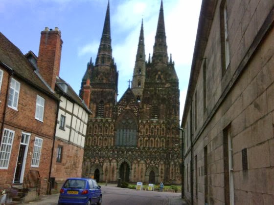
LICHFIELD CATHEDRAL'S THREE SPIRES
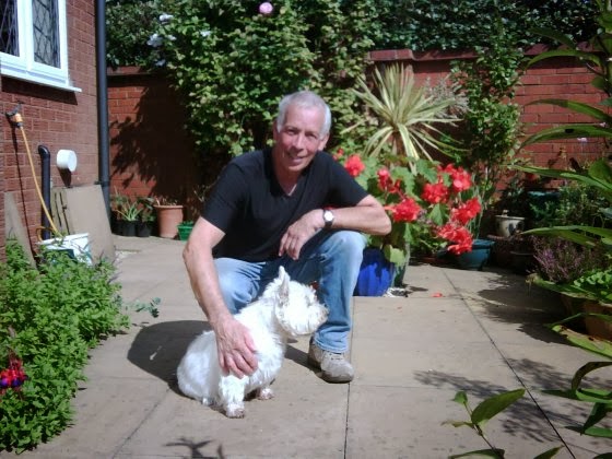
MIKE AND TOMMY (TOMMY HAS FOUR LEGS)
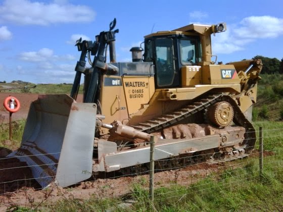
MAGNIFICENT MACHINE AT HINTS GRAVEL PIT
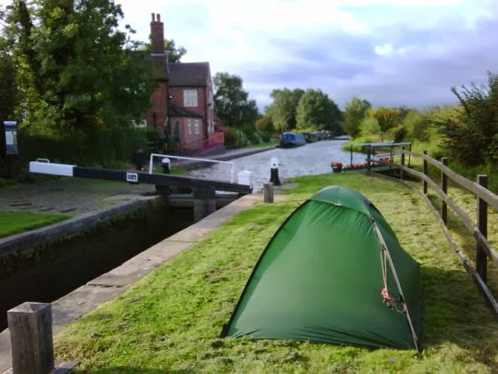
CAMPED NEAR DOG & DOUBLET
BROKEN POLE - BROKEN HEART
KINGSWOOD CANAL JUNCTION
ST. JOHN THE BAPTIST CHURCH, HENLEY-IN-ARDEN
Shortly after I woke up in the garden of The Park Gate Inn, Louise, who had arrived to perform her cleaning duties, opened the back door and brought me a coffee. 

By 8.30pm I was back on the Heart of England Way (HoEW), although I didn't follow it very precisely because it seemed to head off in some daft directions for no obvious reason other than to add distance. I arrived in Lichfield before 11.00am and was immediately impressed by the Cathedral's three spires: that's just greedy, isn't it? I really liked Lichfield. It had a good feel to it. 

After scoffing a Boots 'Meal Deal', I walked through a housing estate to the south of Lichfield and found myself talking to Mike, who interrupted his gardening duties to invite me in for coffee. The weather was the best I'd seen for a while, so I dug out the neglected sunglasses and rubbed on the sun screen while we chatted on his patio.

I reached Drayton Bassett just after 4.00pm with the expectation that I could get a refreshing drink. I noticed a banner saying 'Garden Now Open' but couldn't see any obvious signs of an associated drinking establishment. Some chatty locals assured me that there definitely was one, but didn't seem to know when it opened.

Rather than lose more time, I continued south, ambling my way along the towpath of the Birmingham and Fazeley Canal until I reached the Dog and Doublet pub. It's location by a canal lock was idyllic. I erected my tent on the other side of the lock and then ordered my food, which I ate outside in the evening sun.

I got to sleep early because the following day, 8 September, I needed to be clear-headed for my 6.45am live telephone interview with Julian Clegg on his BBC Radio Solent Breakfast Show.

Afterwards, Jim, landlord of the Dog and Doublet, opened his doors early to let me into the pub and gave me coffee and a huge egg and bacon sandwich to set me up for the day.

I continued alongside the Canal, picking up the HoEW again, then switching to the Centenary Way, then back to the HoEW. Even I'm getting confused now!

I left both designated footpaths completely to visit Meriden, where the original Triumph motorcycles were made, including the T110 that I owned when I was 17. Ah, nostalgia. I wanted to pay homage at the site of the old factory, but it turned out to be 2 miles to the east of the town. I wasn't that nostalgic, so I headed south to rejoin the HoEW near Berkswell.

That was when it happened. Tragedy. I noticed that one of my trekking poles was bent, so I tried to ease it straight again. "I didn't mean to do it; honest Guv, it just fell apart in me 'ands." Normally, such a dramatic shock would spontaneously produce some profane utterance. But no, not me, not now, for my walking experiences have helped me to develop an inner calmness, and the ability to think before I speak. So I thought about it and then uttered a profanity.

Obviously, I can live without the broken pole. I have completed two thirds of my walk and the remaining third is relatively flat. However, I will miss it because I have gotten used to it, and having two poles does take some of the pressure of the heavy rucksack off of my knees.

I continued my way, heartbroken, to a pub called Ye Olde Saracen's Head in a village called Balsall Street. Manager Brett cheered me up when he let me pitch my tent in the garden and eat two main meals for the price of one. Burp.

The weather has been great again. My feet are dry and I'm running out of sun screen.

I slept late on Wednesday morning waiting for the Saracen's Head to open (sounds messy, that). A nice surprise awaited me when Brett gave me a coffee and a comprehensive packed lunch for the day. I followed the HoEW for a short while, but then deviated onto the towpath of the much more interesting Grand Union Canal. This led to the fascinating lock system at Kingswood Junction where the Grand Union meets the Stratford-upon-Avon Canal.

I enjoyed chatting to several canal-boaters as I continued down the Stratford Canal, but had to slow my pace so they could keep up with me. The kind owners of 'Rick o'Shea' gave me a cold lager, which was most welcome in the heat of the day.

After a short distance I picked up the HoEW again which would take me to Henley-in-Arden. Just before I got there I crossed a hill, which was called Motte and Bailey on the map; clearly named after a comedy duo!
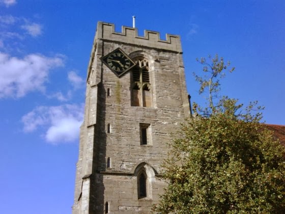
I stopped briefly in the main street of Henley-in-Arden for an ice cream and a cider, and noted the unusual lozenge-shaped clock attached asymmetrically to the tower of the St. John the Baptist church (see picture). Can't understand why the fifteenth century church builders didn't anticipate this requirement and leave a proper space for it.

Since it was only 5.00pm, I decided to walk on a bit further. Big mistake, as I ended up in the small village of Great Alne. Whatever great ambitions this place might have had were clearly unrealised. The only pub in the village, which went by the peculiar name of 'The Mother Huff Cap', was in a severe state of decay. A caretaker manager was in place while the owners sought a buyer, so there was no food available. I was at least able to console myself with a drink and a chat with some locals before I retired to my tent, pitched in the unkempt garden.