Saturday 24 October 2009

THE WALKING MAY BE OVER, BUT…….

A GUINEA PIG AT SOUTHAMPTON UNIVERSITY
KENTON COOL SPEAKS AT COTSWOLD STORE
It’s just over two weeks now since I completed my 1,200 mile trek. When asked on the radio interview how it felt when I touched the finish post at Land’s End, the first word that came to my mind was ‘anticlimax’. The stage-lights didn’t come on, there was no trumpet fanfare and I didn’t magically feel any different. I think it’s a bit like receiving a successful exam result. Only when failure is a distinct possibility does a high level of excitement accompany the confirmation of success. If you are confident of passing anyway, then the blood pressure won’t rise very much. With a long-distance walk, the uncertainty of success is greatest right at the start. By the time you are half-way through, it seems quite likely that you will make it to the end. When just a few miles from the end you know that nothing short of a spontaneous heart attack, being hit by a meteor or (in my case) falling off the Coast Path will stop you getting there. 

Don’t get me wrong. Just because I am not leaping around with glee, it doesn’t mean that I am not extremely happy about the achievement. However, my pleasure is a quieter sort derived from the experience as a whole rather than from any feelings of euphoria in simply having reached the finish post.

Although the walking has taken three months, the venture germinated in my head some two years ago. I started planning the route well over a year ago. Construction of the website started last November. Sponsors started committing their support at the beginning of this year. During the Spring I was out training in the Lake District and on Dartmoor. The dissemination of publicity started about a month before I left. Right up to the moment of my departure, I was distributing posters, placing collecting boxes for the charities and writing further material for the website. 

Thus, when I boarded the train to Scotland on the 13th of July I felt relieved that the huge workload that accompanied my preparations for this venture was now over, and I could now just ‘get on with the job’. With Simon looking after the website, Kay heading the publicity machine (supported by Mike and John), Sarah keeping a track on donations and Chris keeping an eye on my house, I was spared any need to worry about what was happening back home. So, in truth, although I am the one who did the walk, I owe a debt of gratitude to my friends for the success of the project as a whole.

I also owe a debt of gratitude to my generous sponsors who reduced my initial outgoings greatly, and all the other people I met along the way who provided me with shelter, gave me food, donated to my charities or simply passed some time with me. The weather may have been miserable at times; the terrain may sometimes have left me exhausted; my feet and legs often hurt; my kit sometimes let me down. On the other hand, I have been privileged to experience places and see things that few others have. But most of all, it is the people that I will remember most dearly. 

Well, now the walk is done, what’s the score?

Firstly, I am pleased to see that contributions to my charities have exceeded £6,000, but I am keen to push this nearer to my £10,000 target. There is still money to come from people collecting on my behalf. Also, several local organisations have asked me to give an illustrated talk about my adventure. I will naturally be taking my charity bucket with me. 

Health-wise, I have used the past two weeks to restore my body by resting and eating healthily. During the hardest parts of the walk (in Scotland and on the Pennines) I lost an incredible 3 inches off my waist. Any more and I would have been unable to fully tighten my rucksack hip-belt. My weight is now almost exactly the same as when I started, although I suspect that the muscle percentage might be higher. Whether this is true or not may be revealed by the second set of tests that Professor Maria Stokes and her team subjected me to last Wednesday at Southampton University’s School of Health Sciences (the original tests are mentioned in the 12 July ’09 entry under ‘Before the walk’).

There are a couple of physical after-effects from my walk that still remain. The main one is numbness and tingling of my big toes. My guess is that my feet expanded during the walk, making my boots over-tight and thus cramping my toes. Combined with a rather abusive 3.2 million impacts on each foot as I walked, nerve damage has almost certainly occurred which could take six months or so to repair itself. My knees also ache, but this feels ‘muscular’ rather than ‘joint’. Given what I have been carrying on my back for the past three months, I’m not really surprised at this and feel sure that the aches will soon fade away. 

Anyway, with a pile of bills awaiting payment on my return home I have been catapulted straight back into the life I lived before my walk! I suppose it’s inevitable that I should question if that is what I want. Despite the discomforts of being itinerant, there were few things that I missed and I felt little of the kind of stress that seems to accompany 21st century living. Last Thursday I listened to Kenton Cool talking about how he guided Ranulph Fiennes up Everest and the north face of the Eiger. Whilst I felt no inclination to pursue quite such hazardous adventures myself, I was aware that my feet were starting to itch again!!

Friday 9 October 2009

OSGB GRID REF. SW343251. LAND'S END

ST. JUST TOWN CENTRE
COAST PATH AT NIGHT
BY THE FINISH SIGN
ME WITH WELCOMING PARTY JENNIFER, TERRY AND CHRIS
Since I had missed my earlier rest day, I decided to take one on the Thursday instead. Much of my clothing was wet from the previous day's downpour so I dried what I could. Other than that, I spent the morning in the Youth Hostel writing my diary and in the afternoon I took a walk to explore St. Just's small but attractive town centre. I spent an hour browsing in a little combined Cafe/Bookshop and, after wavering for a while because it would add to my rucksack load, I bought a large heavy autobiographical book by Doug Scott called Himalayan Climber. 

In the evening I shared supper with Saskia and then retired to the Hostel's communal lounge to read. A group of American students on an educational trip were staying at the Hostel and I had a very enjoyable conversation with them.

After everyone else went to bed, I remained in the lounge until after midnight. Around 2.50am Friday morning I started to prepare my gear and pack my rucksack. Half an hour later I left the Youth Hostel wearing my head-torch. My plan was to walk the South West Coast Path to Land's End at night. 

It was notably cold but the air was clear. The path from the Youth Hostel was indistinct and hard to follow in the dark, but by maintaining a westerly heading I knew that it would eventually intersect the Coast Path. Once it had, I could then follow the Coast Path south towards Land's End. The lights at Sennen Cove and the Land's End Theme Park were visible ahead of me, along with the flashing light of the Longships Lighthouse, a mile and a quarter offshore.

The Coast Path is quite rocky in the vicinity of Land's End and it is necessary to scramble over piles of boulders in several places. The tide was out so when I reached Whitesand Bay I could walk on the sandy beach all the way to the jetty at Sennen Cove. After the steep climb out of the Cove, Land's End is just 15 minutes walk away. 

My BBC Radio Solent interview was due at 6.45am so I'd timed my approach to the Land's End Theme Park to coincide with this. I was thus able to reach and touch the sign that symbolises the end of my trek whilst I was 'on air'.

So that's it as far as my journey is concerned; three months of experiences that will take me a while to fully assimilate. 

Things are not quite over yet, though, as Chris (a.k.a. George) and friends Jennifer and Terry had arranged to meet me by the sign at midday. I therefore withdrew to Sennen for a while before returning for the 'ceremonial' finish at the expected time.

Roughly an hour later fellow walkers John and Jane, who I'd met in Fort William, turned up. Personal reasons had forced them to curtail their John o'Groats to Land's End walk early on, but they were able to return to complete the latter stages of their planned route. Their walk was not over yet as they will be continuing on to Falmouth over the next week, but it was good to have them share the celebratory bubbly that Chris had brought with her. 

I think this is a good time to remind readers that my walk has been in aid of Cancer Research UK and the British Heart Foundation. This task will continue until I reach my £10,000 target. In any case, this blog is not yet finished as I will be writing an 'after the walk' summary once I have come down to earth again.

Wednesday 7 October 2009

OSGB GRID REF. SW364305. ST. JUST

COAST NEAR PORTHLEVEN
REMNANT OF CORNISH MINING INDUSTRY
CRASHING WAVES
ME AT ST. MICHAEL'S MOUNT
SASKIA, PHIL, ME & BECKY AT LETCHA VEAN
It rained for the third successive night, so the tent was wet again on Tuesday morning. This wasn't a problem, though, as by the time I'd used the campsite shower and composed my latest blog entry, things were starting to dry. 

Although I was due a rest day, I didn't actually feel the need for one and decided to keep walking instead. I took my time though, so it was early afternoon before I left Porthleven to continue west along the Coast Path. My initial plan had been to proceed using inland roads, so having the time to walk the Coast Path instead was a bonus. The route is wonderfully scenic, but the path constantly changes direction and elevation as it follows the profile of the coast, thus taking much longer to walk than the crow-flies distance might suggest. However, I'm sure the pictures will illustrate why I think this path is well worth the energy expenditure. 

When I reached Marazion I had been quite prepared to stay at another campsite, but found an excellent B&B instead. I had struck lucky. Chyanoweth is the home of Pete and Sue, and their guest room had all the features of a luxury flat. I was particularly taken with the gold-sequined bed cushions. That evening I found myself in a quiz team with my hosts and their friends at the Kings Arms. 

In the morning I had a telephone interview with Chris Broom of Hampshire paper 'The News' who is writing a two-page article about my venture. I am grateful for the publicity as I am still only half-way to meeting my charity target. It was raining quite heavily when I left Marazion to walk the 3 miles to Penzance. 

I am scheduled to have a further Radio Solent interview on the morning of my arrival in Land's End this Friday, but I wasn't sure if I would be able to get reception on my mobile phone. To check this out, I took a bus ride to Land's End and back as soon as I reached Penzance. I didn't actually step off the bus, but was able to confirm that communications would be OK. It also gave me an opportunity to shelter from the rain for a while. 

I had hoped that the rain might have ceased by the time the bus returned to Penzance, but it was as heavy as ever. I was feeling cold from sitting still and needed to decide what to do next quickly. 

I'd never been to St. Just before. Located near the coast about 8 miles west of Penzance and 5 miles north of Land's End, it has a Youth Hostel nearby. It was coming up to 4.00pm so I quick-marched there by the most direct route I could find. That soon warmed me up. Two and a half hours later I was at St. Just's Letcha Vean Youth Hostel, and an hour after that I was sharing supper with fellow guests Saskia, Becky and Phil. We got on well and chatted until quite late. 

Land's End is now just a short walk to the south. Indeed, I could see it from the hill overlooking the Youth Hostel. It would be nice if I could do something slightly unusual to end the walk. Naked has already been done and, anyway, it might be cold. I have another idea brewing, but I'm not telling yet!

Monday 5 October 2009

OSGB GRID REF. SW628263. PORTHLEVEN

SATELLITE DISH AT GOONHILLY
CADGWITH HARBOUR
LIZARD LIGHTHOUSE FROM LIZARD POINT
VIEW FROM LIZARD POINT
MULLION HOLIDAY PARK LET ME CAMP FOR FREE
PORTHLEVEN HARBOUR
Isn't it strange how things often come to you just when you need them? The first heavy overnight rainfall for a while, and I was tucked up under a corrugated steel roof in Mr Hall's storeroom. Noisy, but dry. More importantly, I was spared the dubious pleasure of having to pack away a wet tent. 

The rain continued during the morning as I headed south through Stithians and Rame. By lunchtime I'd reached Gweek, which sounds like a Jonathan Ross attempt to describe Zorba's nationality. 

It was Sunday, so I decided to treat myself to a carvery dinner at The Gweek Inn. Rosemary's rucksack banner ensured that my cover was blown the moment I entered the establishment; I received a charity donation within moments. Not only that, the Inn waived payment for my food and drinks bill. That's the second time in two successive days that I haven't paid for my meal! I am delighted to be the recipient of such kindness but feel the charities should benefit too, so I will donate part of the value to the fund. 

After Gweek, I wanted to have a close look at the large satellite communications dishes at Goonhilly Earth Station. I had intended to use a path that starts from Mawgan and passes over Trelowarren, but this turned out to be a permissive one and the landowners had rescinded their permission on 1 Oct. I was not impressed. The resulting 2 mile detour cost me nearly an hour. 

By the time I got to Goonhilly I had formulated a plan. Part one of the plan involved quick-marching southwest across the Goonhilly Downs to a campsite near Mullion. When I got there, however, I thought the campsite looked distinctly grotty. It was 7.15pm and the light was going so there wasn't much time for a re-think. Fortunately, the much nicer Mullion Holiday Park was just next door and they let me stay for free. 

Part two of my plan involved leaving most of my gear at the campsite next morning so that I could walk the 10 miles to Lizard Point and back with minimal weight. It rained heavily for the second night running and this continued into the morning. No worries. I simply donned my wet gear, left the tent where it was and exited the campsite by a short-cut that staff member Paul had shown me the previous night. This took me to a back road south of the Holiday Park. From there I headed to Lizard Point, but not directly as I'd decided to visit the pretty fishing village Cadgwith along the way. 

When I got to Lizard Point I took the usual celebratory photographs and then popped into the cafe for a celebratory pot of tea and a bit of celebratory carrot cake. Just to remind those who have just joined the blog, Lizard Point is the most southerly point in Britain and Dunnet Head the most northerly. As the crow flies, these points are 4 miles further apart than John o'Groats to Land's End, hence the reason why I have included them on my trek. Thus, I have now completed a walk between the two most distant points in mainland Britain. It'll now take me just a few more days to get to Land's End to complete the better known but slightly less extreme walk. Lesson over. 

By the time I'd walked back to the Holiday Park, the rain had stopped, the sun was shining and my tent was dry. Packing my gear, I headed west to join the South West Coast Path at Poldhu Cove. At last, I was walking a proper footpath again and my feet immediately seemed lighter. My appreciation of Cornwall's exciting sport of dodging traffic had worn very thin by now. Besides, it is difficult to appreciate the country views when most of one's attention is focussed upon staying alive. 

The South West Coast Path is probably the most consistently attractive long-distance trail in Britain. Because the tide was coming in, I stuck to the cliff top trail rather than walk along the beach, except where the trail cut across Loe Bar. By 6.00pm I was in Porthleven. I was due a rest day, but didn't even enquire about B&B prices as I knew they would be painfully expensive. In any case, I found a nice little camp site in Mill Lane just a short walk from the harbour.

My friends are expecting me to arrive at Land's End at midday on Friday 9 October, but I am well ahead of schedule and in danger of getting there before them. Not a problem. With stunning coastal views to enjoy, I'm sure I can drag my feet a little over the next few days.

Saturday 3 October 2009

OSGB GRID REF. SW760401. FROGPOOL

INTERESTING PLACE NAME
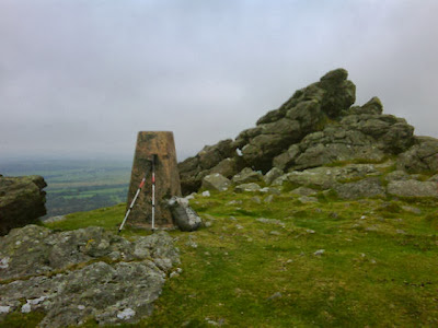
HAWKS TOR ON BODMIN MOOR
CAMPING ON TRESLEA DOWNS
GREAT SOUNDING NAMES
FRIEND SARAH WILL APPRECIATE THIS ONE
NOT ALL ROAD WALKS ARE UNATTRACTIVE
KINDLY GENTLEMAN MR HALL
The first day of October and Bodmin Moor was in my sights. First, however, I had to get to North Hill, the village I had chosen to be my 'launch point' onto the Moor. Unfortunately, due to a dearth of suitable footpaths, getting there from Launceston involved walking southwest along the B3254 for 5 miles. As it happened, traffic was light and drivers were courteous so the roadside walk was not as bad as I had feared.

My route across Bodmin Moor took me to Hawks Tor, Newel Tor and Hill Tor. I would have liked to include Kilmar Tor and Brown Gelly on my route, but walking the very rocky 1km length of the former would have taken too much time, and the latter was surrounded by barbed-wire fences. I had to climb a few walls and fences anyway because Bodmin Moor is not a National Park and there are few official footpaths across it. I kept a low profile and did my best to avoid attracting the attention of any farmers whose fields I might be crossing.

The weather was fine and the air clear, giving great views. Although I was not following paths, the good visibility made navigation easy. I wished there had been more days like this when I was walking the Pennines. I had expected Bodmin Moor to be bleak and boggy, but it was neither of these on this occasion. Of course, had the weather been wet and foggy my impression might have been quite different.

All too soon I came back onto the roads again just south of Colliford Lake. I continued past Pantersbridge, but the light was fading by the time I reached Mount. A local informed me that there was a small area of open moorland just beyond Mount where I could camp. I quickly climbed what turned out to be Treslea Downs and pitched my tent amongst the wild ponies that reside there.

The following day's trek involved yet more roads, although these were mainly unclassified and had very low traffic densities. It seems odd that I should have my greatest difficulty finding suitable footpaths in one of the most rural parts of England. By mid-afternoon I had reached Bugle, and the opportunity to replenish my food and water. I continued on through Whitemoor and Nanpean until I reached the most appropriately named St. Stephen.

I had walked through the heart of the China Clay industry. The evidence of this destructive activity was all around. The hills had been systematically demolished to remove the valuable commodity leaving distorted, unnaturally terraced hills and pointed slag heaps, all too unstable and dangerous to walk upon. It is hard to appreciate the scale of the destruction this industry has wrought on the landscape until you see it with your own eyes. Much of the China Clay business is now owned by a French company called IMERYS which, when rearranged, spells MISERY, as one friendly farmer pointed out to me. Whilst misery may be too strong a word, the area certainly had a depressed feel about it which is infectious.

Anyway, the Landlady at the Kings Arms Inn at St. Stephen let me camp in the field at the side of the pub. That cheered me up.

The weather teased me with a little shower of rain in the morning. I packed the tent quickly before it got too wet, only for the rain to stop anyway and a glimmer of sunshine to appear. This mixed weather set the pattern for the day. It was drizzling as I continued my road walk west through Laddock and St. Erme, but dry by the time I'd reached St. Clement Woods to join National Cycle Network route no. 3 south to Truro.

What a cheerful place Truro is! I stopped for a while to eat lunch, explore the bustling town centre and enjoy the street music. I would have liked to have stayed longer, but I had this charity walk thing to do.

Cycle route 3 took me down to Bissoe (no, not Bisto, silly). About a mile south west of Bissoe I came to Frogpool, an apt name given what the weather was doing at the time. Local enquiries (at the Cornish Arms) resulted in my introduction to 84 year old farmer Mr Hall, who offered me the use of a dusty attic storeroom as my residence for the night. He even had an outdoor loo I could use! Magic. What more could any wild-camper wish for on a rainy night? Well, there was the additional pleasant surprise that my food and drinks bill at the Cornish Arms was mysteriously paid for me. I suspect that somebody by the name of Andy might have had something to do with that.

Wednesday 30 September 2009

OSGB GRID REF. SX329852. LAUNCESTON

TRIG. POINT ON SOURTON TOR
BAA, BAA
BROTHER PAUL & MUM IN LAUNCESTON
LAUNCESTON CASTLE
Although shared dorms are the norm in a Youth Hostel, occupation at the Okehampton establishment was low so I had a room all to myself. I didn't wake until 8.30am on Monday 28, which probably goes to show how much I needed the rest. I had to dress quickly to be in time for breakfast. 

It was great not to have to worry about dismantling the tent and packing the rucksack. I spent the day washing socks, writing my blog, sending some emails and dropping in on friend Alan at his electronics factory in Okehampton, but really not doing that much at all. 

I had decided to walk the whole of the Two Castles Trail in one go on Tuesday. This 24 mile path runs between Okehampton Castle and its counterpart in Launceston. It is the only footpath in the West Country that I walk in its entirety, the other footpaths I encounter being just short sections of longer paths. 

Rising early, I set off shortly after 8.00am. I had left my main rucksack at Alan's factory when I visited him so that I would only need to carry a few essential items in my lightweight daysack.T

The walk initially took me through a golf course and then up on the northern edge of Dartmoor National Park. Here I could free-roam for the first time since the Pennines, unconstrained by any path, much like the sheep surrounding me. One group of 5 sheep, 3 rams and 2 ewes, all decided to urinate simultaneously as I passed by. I came to the conclusion that this was probably some sort of collective insult to humans. I don't blame them. I too might be tempted to insult someone who was planning to eat me. 

The 'official' route of the Two Castles Trail is a bit tame so I took a detour up to Sourton Tor where the rocky summit provided me with a brief reminder of what Dartmoor is all about. Leaving the moor and continuing west, the remainder of the walk to Launceston was dull by comparison, at least until Launceston Castle came into view, dominating the town from its hill. 

The walk had taken me just under 10 hours, including lunch stops, and I had crossed my final county boundary into Cornwall. Not having brought my tent, I booked a room at the White Horse Inn. 

I remained in Launceston on Wednesday to spend some time with Mum and brother Paul who had travelled up to see me. On their way they collected my rucksack from Okehampton, along with a further supply of energy foods that Matt Furber of Lucozade Sport had sent to Alan's factory.

When the family visit was over it was time to make preparations for the following day's trek. This would take me on to my next significant challenge, which is to cross bleak Bodmin Moor. I hope that the fair weather continues for a while.

Sunday 27 September 2009

OSGB GRID REF. SX593944. OKEHAMPTON

SWANS ON GRAND WESTERN CANAL
MARY & RAY FROM HALBERTON
BICKLEIGH BRIDGE
MY FELINE COMPANION AT THE RED LION, SHOBROOKE
FRIENDS PETER & ANTHEA
OKEHAMPTON YOUTH HOSTEL IN OLD RAILWAY BUILDING
With liberal amounts of tea and a bowlful of porridge inside me, I said farewell to Susan and Paul and headed west again. I principally followed the West Deane Way, but deviated onto minor roads and other paths when it suited me (or I made a mistake). My route more-or-less followed the River Tone to Greenham Weir where I was able to join the Grand Western Canal. I love canals because they are picturesque, I can walk quickly along the level towpaths and the possibility of making navigational errors is slight.

I followed the canal south until I reached Sampford Peverell, which has two pubs, both serving food, but decided that I still had time to walk a bit further. According to my map, the next village, Halberton, also had a pub. However, when I got to 'The Barge' I discovered that they could not serve food because the kitchens were being refurbished. They didn't have a lawn on which I could pitch my tent either. Naturally, I did what anyone else would do; buy a pint of cider and then break down and sob uncontrollably into it. My pathetic display soon attracted the sympathy of a chap called Ray who lives opposite and offered the use of his garden as a campsite. I also noted that there would be a pub quiz later that evening with an accompanying buffet supper, so for the modest entry fee of £2 (which Ray paid) I joined a team and solved my food problems too. Our team came 2nd and I received several charity donations from Barge regulars.

Next morning Ray's wife, Mary, gave me some breakfast and we had a photo-session before I walked the final part of the Grand Western Canal into Tiverton, an excellent place to find a cafe where I could carry out my blog-writing duties.

From Tiverton I headed south along the Exe Valley Trail, although I was somewhat surprised to find that a valley walk involved 150m of climbing! After about 8 miles I reached Thorverton where I turned west along some minor roads for another 4 miles to reach Shobrooke. "What's at Shobrooke?", you might ask! Well, you've probably guessed, and it's called The Red Lion Inn. I can hear some people saying, "This charity walk is just an excuse for a mammoth pub crawl". Well, I have only one thing to say to such cynics, and it's "Mine's a Guinness".

Outside the Red Lion was an unassuming chap with a tea-towel tucked into his belt smoking a cigarette. Guy turned out to be the landlord. Pitching my tent on the lawn was no problem and Guy's wife, Lesley, was happy to feed me. I was also adopted for the evening by one of the pub's cats.

That night was the coldest so far and I had to tighten the draw cord on the hood of my sleeping bag for the first time. When I poked my head out of the tent early Sunday morning there was a thick mist and the fly sheet was soaking wet. I wanted to be away by 9.00am so, inevitably, it was still wet when I packed it. Guy kindly treated me to some breakfast before I departed for what would be short road walk to Crediton, then a longer one to Spreyton.

I reached the Tom Cobley Tavern in Spreyton shortly after 1.00pm to be treated to food for the second time that day - this time it was a roast dinner courtesy of friends Anthea and Peter Benham, who had come to visit me during my trek. Peter had brought his boots, so he accompanied me to Okehampton afterwards, a walk of about 8 miles with the latter half mainly along the route of the Tarka Trail. We were met in Okehampton by Anthea, who had taken my rucksack in their car, allowing me to travel light.

After they drove off, I walked up to Okehampton Youth Hostel to enjoy my first night indoors for a week. Monday would be a rest day.